What Causes A Tornado To Form
You know that feeling, right? That specific hush before a really big storm hits. The air gets heavy, a weird green tint might wash over the sky, and you can practically feel the atmosphere holding its breath. I remember one summer evening, sitting on my porch, watching the clouds gather. They weren't just fluffy white sheep; these were dark, angry, bruised-looking behemoths swirling in a way that just felt... wrong. My gut tightened. I wasn't seeing a tornado, thankfully, but that particular sky made me wonder, really wonder, what cosmic ballet had to happen to twist all that air into something so terrifyingly powerful.
And that, my friends, is exactly what we're diving into today. Forget the urban legends about trailer parks attracting them (they don't, by the way, it's just sad correlation). We're talking about the actual, nitty-gritty, atmospheric science of how Mother Nature throws a truly epic, and often devastating, temper tantrum in the form of a tornado. It's less about magic and more about a very specific, and rather dramatic, recipe of weather ingredients.
The Essential Ingredients: Air, Air, and More Air
To get a tornado brewing, you don't just need any air; you need a few very particular types to throw a party in the sky. Think of it like baking a cake – you can't just throw flour at it and hope for the best, right? (Unless you're going for a really experimental, probably inedible, cake.)
Must Read
First up, we need warm, moist air. Picture it: humid, sticky, probably from somewhere like the Gulf of Mexico if you're thinking about the famous "Tornado Alley" in the US. This air is light and buoyant, just itching to rise. It's the enthusiastic party guest who's ready to dance.
Then, we need some cool, dry air. This stuff usually comes from higher latitudes or altitudes, perhaps off the Rockies or from Canada. It's denser, heavier, and definitely not in the mood for dancing. It wants to sink.
When these two very different air masses meet, it's like an awkward family reunion where nobody gets along. The warm, moist air tries to push its way up, but the cool, dry air acts like a lid, initially trapping it. This creates a whole lot of instability in the atmosphere. It's a pressure cooker situation, figuratively speaking, building up energy just waiting for an escape route.
The Twist: Enter Wind Shear
Okay, so we've got our unstable air – a classic thunderstorm setup, usually. But to get a tornado, we need something extra special, something that turns a regular storm into a potential swirling monster. And that, my friends, is where wind shear comes into play. This is where things get really interesting, so lean in.

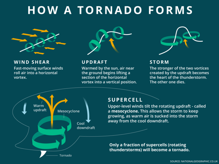
Wind shear is basically when winds at different altitudes blow at different speeds AND/OR in different directions. Imagine the wind near the ground blowing east, but a few thousand feet up, it's screaming south at a much higher speed. This difference creates a horizontal, invisible spinning effect in the atmosphere, like a gigantic, invisible rolling pin in the sky. Pretty wild, right?
This isn't just a gentle breeze; this is powerful, rotating air that you can't even see yet. It's the critical ingredient that distinguishes a potentially severe thunderstorm from one that can birth a tornado.
The Grand Reveal: From Roll to Roar
So, we've got our unstable air and our horizontal rolling pin of wind shear. How do these combine to create that iconic, vertical funnel? This is where the magic (or rather, the incredibly complex atmospheric physics) truly happens.
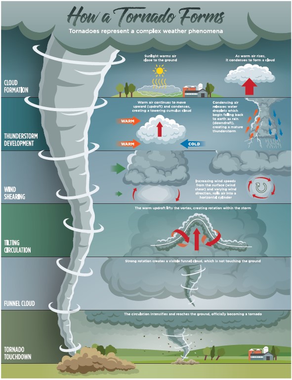
Remember that warm, moist air that was itching to rise? Well, it finally gets its chance. Powerful updrafts within the developing thunderstorm begin to suck that horizontally spinning air upwards. Think of it like someone tilting that giant rolling pin on its end and pulling it towards the sky. Suddenly, that horizontal rotation becomes vertical.
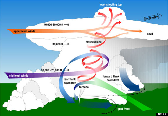
And voila! You've got yourself a rotating column of air inside the storm, known as a mesocyclone. This is the heart of a supercell thunderstorm, the type of storm that produces most tornadoes. It’s a powerful, persistent rotating updraft. Pretty cool, huh? And a little bit terrifying.
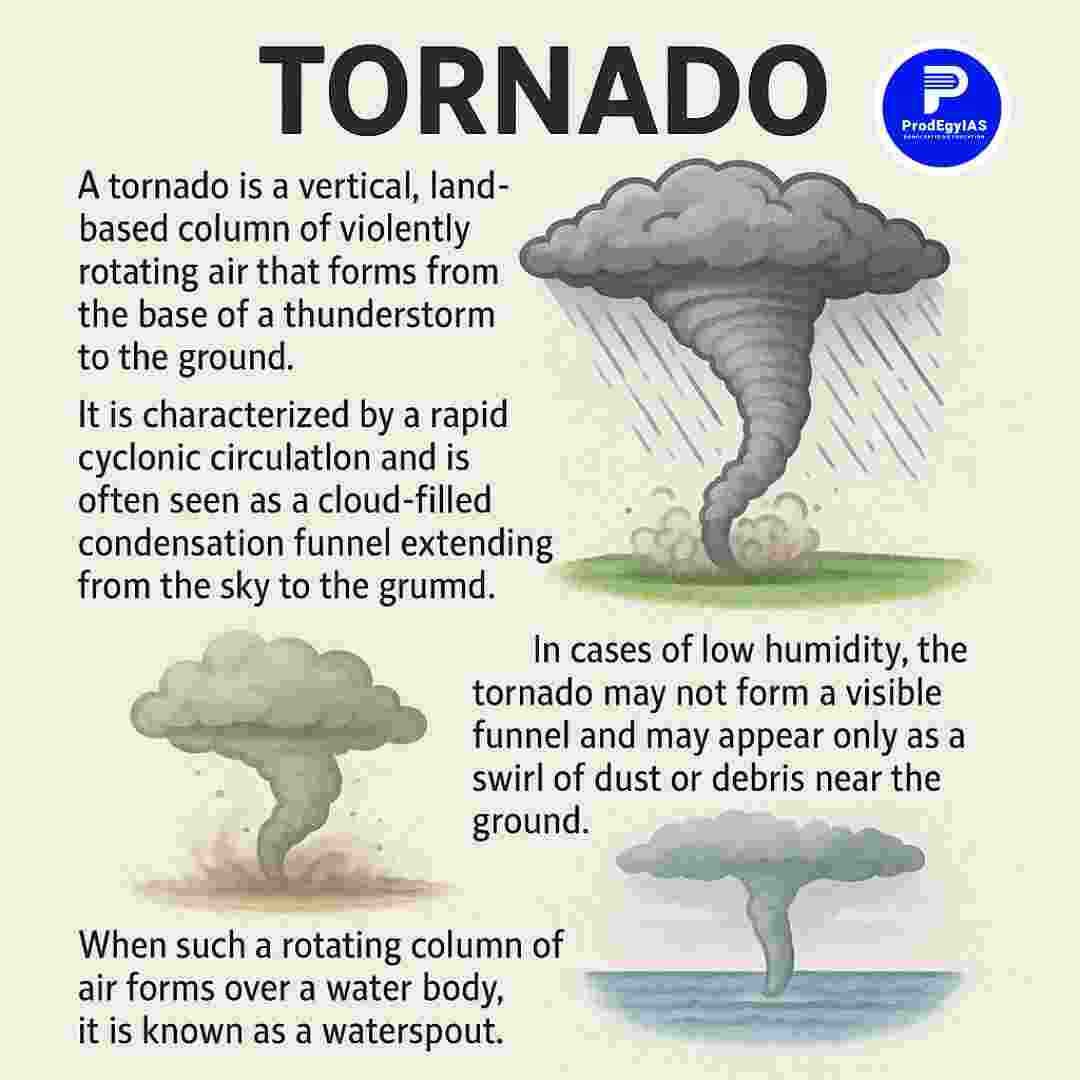
As this mesocyclone intensifies and rotates faster, the pressure within its core drops dramatically. This low pressure acts like a vacuum cleaner, sucking more air inward and upward, causing the rotation to spin even faster (thanks, conservation of angular momentum!). If the conditions are just right – enough moisture, enough lifting – the air pressure within the funnelling column drops so low that water vapor condenses, making the invisible rotation visible. And that, my friends, is when you finally see the majestic, terrifying funnel cloud extending downwards from the base of the storm.
When that funnel makes contact with the ground, picking up dust and debris, that's when it officially becomes a tornado. It's the grand finale of a truly incredible, and often devastating, atmospheric dance.
So, next time you see that ominous sky, or hear a storm warning, you'll know it's not just "bad weather." It's a complex, powerful interplay of air masses, wind shear, and atmospheric dynamics, all coming together in a dizzying display of nature's raw power. It's humbling, isn't it?