What Is The Most Violent Part Of A Hurricane

Hurricanes are wild. They're like giant, swirling storms that can cause serious damage. But have you ever wondered what the most intense part of a hurricane is?
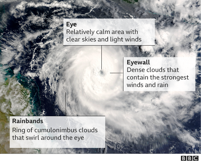
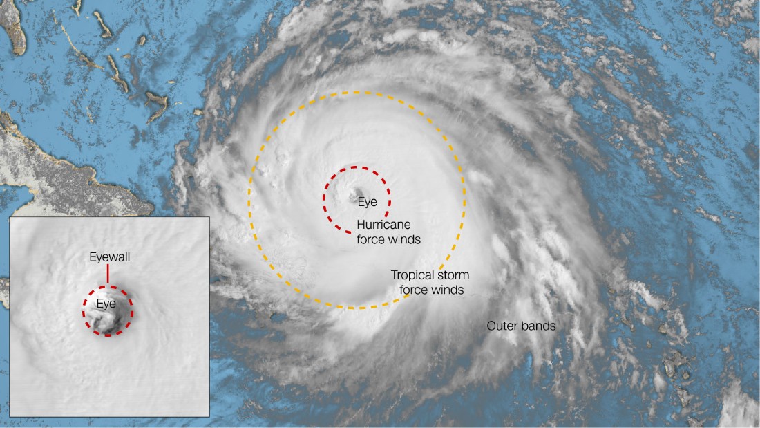
The Eye of the Storm...Or Is It?
You might think it's the eye. After all, that's where everything looks calm and peaceful. But don't be fooled! The eye is just a temporary break from the real action.
Actually, the most violent part of a hurricane is the eyewall. It's the area surrounding the eye. This is where the strongest winds and heaviest rainfall are located.
Must Read
What Makes the Eyewall So Intense?
Think of the eyewall as the engine of the hurricane. It's the place where the storm's energy is most concentrated. The air rushes upwards and inwards towards the eye.
As the air rises, it cools and condenses. This forms towering thunderstorms. These thunderstorms release a tremendous amount of heat. This heat fuels the hurricane and makes the eyewall even stronger.
The eyewall's winds can reach incredible speeds. We're talking well over 100 miles per hour! That's enough to cause major damage to buildings and infrastructure.
Why is the Eyewall so Fascinating?
The eyewall is fascinating because it's a paradox. It surrounds the calmest part of the storm, yet it's the most dangerous. It shows the power of nature in all its glory.
Imagine being in the eye of a hurricane. Everything is quiet. Then, suddenly, the eyewall slams into you with full force. It's a terrifying, but also awe-inspiring, experience.
Scientists study the eyewall to better understand hurricanes. They want to improve forecasting and warnings. This helps people prepare for these destructive storms. And keep them safer.
Visualizing the Eyewall
It can be hard to imagine what the eyewall looks like. Think of a stadium filled with angry, swirling clouds. These clouds are packed with rain and wind.
Now, imagine that stadium is spinning around and around. That's essentially what the eyewall is doing. It's a chaotic and powerful vortex.
You can often see incredible images of the eyewall on satellite. These images show the sheer scale and intensity of the storm. They are a stark reminder of the power of nature.
The Dangers of the Eyewall
The eyewall poses several dangers. The intense winds can rip apart buildings. They can also uproot trees and turn debris into dangerous projectiles.
The heavy rainfall can lead to flash flooding. This is particularly dangerous in low-lying areas. Storm surge, which is a rise in sea level, can also be devastating.
If you're ever in the path of a hurricane, it's important to take the eyewall seriously. Listen to local authorities. Follow their instructions. Stay safe!
Eyewall Replacement Cycles
Hurricanes can sometimes undergo what's called an "eyewall replacement cycle." A new eyewall forms outside the existing one.
The outer eyewall gradually chokes off the inner eyewall. The inner eyewall weakens and dissipates. The outer eyewall then becomes the new, dominant eyewall.
These cycles can cause the hurricane to weaken temporarily. But the storm can often re-intensify once the new eyewall is in place. This makes predicting hurricane behavior even more challenging.
Studying the Eyewall Up Close
Scientists use various tools to study the eyewall. They use weather balloons. They use aircraft equipped with sophisticated instruments. They even use radar.
These tools allow them to measure wind speeds, rainfall rates, and other important parameters. This data helps them to better understand the dynamics of the eyewall. It also helps them to improve forecasting models.
One of the most daring ways to study the eyewall is to fly directly into it. Specially designed aircraft can withstand the extreme conditions. They collect invaluable data.
Eyewall and Climate Change
Scientists are also studying how climate change might affect the eyewall. There is evidence that warmer ocean temperatures could lead to stronger hurricanes.
This means that the eyewalls of future hurricanes could be even more intense. This would increase the risk of damage and flooding along coastlines.
Understanding the eyewall is crucial for preparing for the impacts of climate change. It will help us mitigate the risks posed by these powerful storms.
Eyewall: A Reminder of Nature's Power
The eyewall is a powerful reminder of nature's raw force. It's a zone of intense winds, heavy rain, and towering thunderstorms. It surrounds the calm eye of the storm.
It's both terrifying and fascinating. It drives the hurricane's destructive potential. Scientists continue to study the eyewall. They strive to understand its complexities. Their efforts help us stay safe.
Next time you hear about a hurricane, remember the eyewall. It's the heart of the storm. It's where the most intense action takes place. It's a truly remarkable phenomenon of nature.
Can You Survive Inside Eyewall?
The question of survival inside the eyewall is a very serious one. The conditions within are extremely hazardous. It's a place of intense winds, heavy rain, and storm surge.
It is highly unlikely that anyone could survive without substantial protection. Structures within the eyewall can be completely destroyed. Debris becomes a dangerous projectile.
That is why evacuation orders are crucial in the face of an approaching hurricane. Do heed to the warnings of the authorities. Your survival depends on it.
Misconceptions About the Hurricane's Eye
There's a common misconception that when the eye passes, the hurricane is over. This is not true. After the eye passes, the eyewall will come back around.
This second half of the storm can be just as dangerous, if not more so. Many people are injured or killed after the eye passes because they think the danger has passed.
Therefore, stay inside and wait for official confirmation that the storm has completely passed. Don't venture outside just because the eye has moved over you.
The Importance of Early Warning Systems
Early warning systems are vital for protecting communities from hurricanes. These systems rely on advanced technology. They rely on skilled meteorologists.

They track storms and predict their paths and intensities. This information is used to issue warnings and evacuation orders. These are intended to provide people with enough time to prepare.
Always pay attention to weather forecasts. Listen to emergency officials. Take their warnings seriously. Your life may depend on it.
How Can We Prepare For Hurricanes?
Preparing for hurricanes is essential, especially if you live in a coastal area. This involves creating a disaster plan. It also involves assembling a supply kit.
Your disaster plan should include an evacuation route. It should also include a communication plan. Your supply kit should include food, water, and first-aid supplies.
Protect your home by boarding up windows. Securing loose objects. Trimming trees. Taking these steps can minimize damage during a hurricane.
The Future of Hurricane Research
Hurricane research is an ongoing effort. Scientists are constantly working to improve forecasting models. They are also learning more about the complex dynamics of these storms.
This research will help us to better prepare for and respond to hurricanes. This will save lives. It will protect communities. It also reduces the economic impact of these events.
By supporting hurricane research, we can invest in a safer future for coastal communities. And help save lives.