Diagram Of How A Hurricane Forms
Ever find yourself scrolling through Instagram, seeing those stunning drone shots of tropical beaches, and then BAM! A weather alert pops up about a hurricane? It’s wild, isn’t it? These massive, swirling behemoths of nature capture our attention, demanding both respect and a little bit of awe.
But have you ever stopped to wonder, how do they actually get started? It feels like magic, but it’s pure, fascinating science. Grab your favorite herbal tea (or a strong coffee, depending on your vibe today), because we're about to demystify the gorgeous, terrifying ballet of hurricane formation. No science degree required, just a curious mind!
The Warm Water Welcome Mat
Think of a hurricane needing a super cozy, warm bed to even consider waking up. It all kicks off with ocean water that’s at least 80°F (26.5°C) and goes down to a depth of about 150 feet (50 meters). This isn't just bathwater warm; it's a deeply heated, consistent warmth. Like your favorite weighted blanket, but for the entire ocean.
Must Read
That's why you only see these colossal storms in tropical and subtropical regions. The Caribbean, Gulf of Mexico, parts of the Pacific – these are the hurricane nurseries. No hurricanes chilling in the Arctic, thank goodness! This warm water is the hurricane's ultimate fuel, its energy drink, its entire reason for being.
Rising Up, Pressure Down: The Invisible Elevator
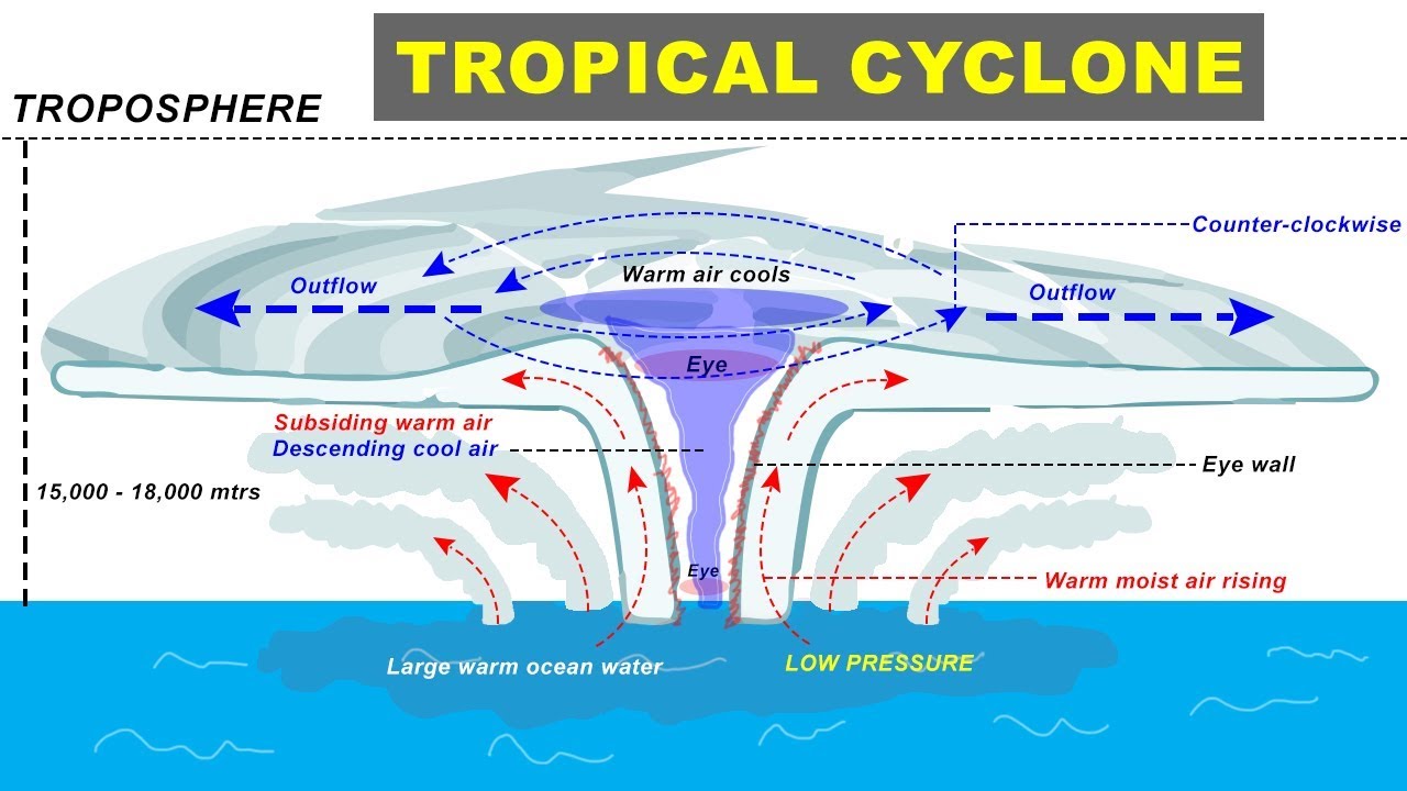
Okay, so we've got our perfectly heated ocean. What's next? Heat equals evaporation, right? All that warm ocean water starts to evaporate, creating moist, warm air that rises rapidly. Think of the steam swirling up from your morning coffee, or that satisfying cloud from your humidifier – but on a much, much grander, more powerful scale.

As this warm, moist air ascends, it leaves behind an area of lower atmospheric pressure at the surface. Nature absolutely abhors a vacuum, or in this case, a pressure differential. This rising air then cools, condenses into massive clouds and rain, releasing latent heat back into the atmosphere. This released heat actually fuels the storm more, creating a powerful feedback loop. It's like the storm is getting a self-charging battery!
The Earth's Gentle Spin: Getting Groovy with Coriolis
Here's where things get really groovy and the storm starts to look like the iconic swirls we recognize: the Earth's rotation. As cooler, denser air rushes in to fill that low-pressure void we just talked about, it doesn't just go in a straight line. Thanks to the Coriolis Effect, this incoming air gets deflected.
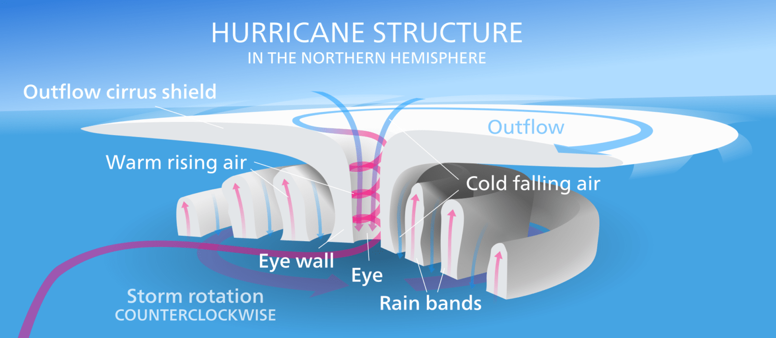
Imagine trying to walk in a perfectly straight line on a giant merry-go-round – you'd naturally drift, right? In the Northern Hemisphere, this deflection is to the right, causing the storm to spin counter-clockwise. In the Southern Hemisphere, it's clockwise. This is crucial for forming that characteristic hurricane spiral.
Fun fact: This is also why you won't see hurricanes forming right on the equator (within about 5 degrees latitude) – the Coriolis Effect just isn't strong enough there to get that essential spin going.
The Vortex Takes Shape: From Swirl to Storm
With warm, moist air continuously feeding in, rising, condensing, and spinning, the storm starts to organize. The low-pressure center deepens, winds pick up speed, and you start to see that iconic spiral shape. Once sustained winds reach 74 mph (119 km/h) or higher, congratulations, you've officially got a hurricane!
At the very center of this intense swirl, a calm, clear area forms: the eye of the hurricane. It’s eerily peaceful, a stark contrast to the violent eyewall surrounding it. It's like the quiet center of your own personal storm, right?
Nomenclature & Preparedness: Being in the Know
Ever wonder how hurricanes get their names? They're assigned alphabetically from a rotating list by the World Meteorological Organization. It helps avoid confusion when multiple storms are active. So, next time you hear 'Hurricane Emily,' you know it’s just her turn!

While fascinating to understand, hurricanes are no joke. If you live in a coastal area prone to them, having an emergency kit, a communication plan, and knowing your evacuation routes are absolute must-dos. Being informed is always your best defense – a little bit like diagramming life, right?
A Moment of Reflection
So, from a simple patch of warm ocean to a powerful swirling vortex, hurricane formation is a beautiful, complex dance of atmospheric physics. It reminds us that even the most immense forces start with small, fundamental conditions – warm water, rising air, a gentle spin.
It's a powerful metaphor for life, isn't it? Our own 'storms' or big challenges often build up from subtle shifts – a new idea, a change in perspective, or even just persistent effort. Understanding the 'diagram' of things, whether it's a natural phenomenon or a personal goal, helps us navigate and appreciate the incredible forces at play. Stay curious, stay safe, and let the wonders of our world keep inspiring you, one diagram at a time.