What Part Of The Hurricane Is The Strongest
Okay, so hurricanes. Big, swirling, sometimes scary things. We all know to take them seriously, right? But have you ever wondered, like, really wondered, what part of this swirling monster packs the biggest punch? It's not just a general "hurricane-ness" that's dangerous. There's a specific zone you really need to watch out for. Think of it like knowing which end of a water balloon to avoid when your little brother’s got one pointed your way.
The Eye of the Storm… and its Not-So-Peaceful Neighbor
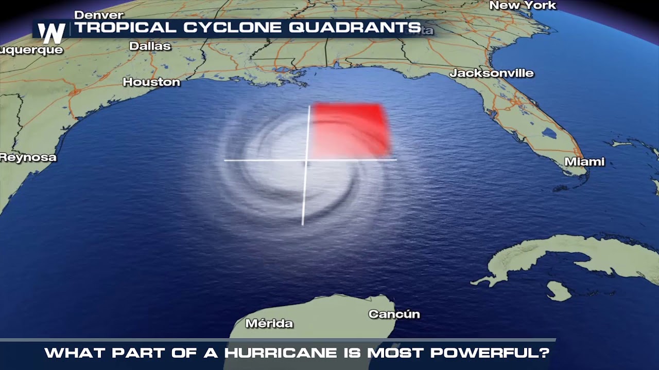
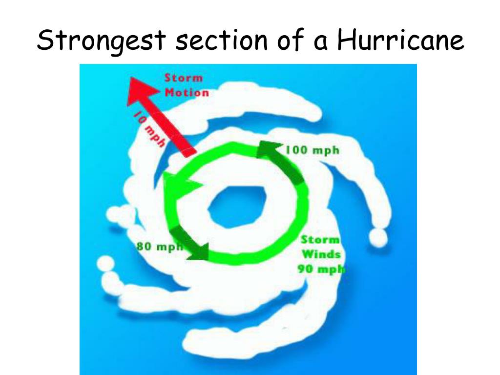
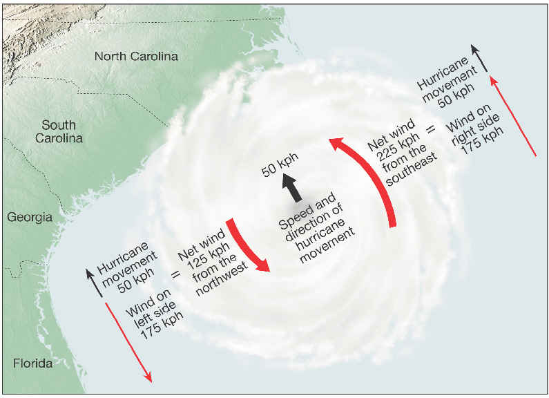
You've probably heard of the eye of the hurricane. It's that calm, eerily peaceful center. Think of it as the donut hole of a very, very angry donut. It's tempting to think, "Ah, sweet relief!" if you find yourself in the eye. But hold your horses! Because the eye is surrounded by something far more sinister: the eyewall.
The eyewall is where all the real action happens. It's a ring of intense thunderstorms, the strongest winds, and the heaviest rainfall all crammed together in one terrifying party. Imagine a mosh pit, but instead of sweaty teenagers, it's swirling winds and torrential downpours. Nobody wants to be in that mosh pit!
Must Read
Why is the eyewall so powerful? Well, it's where the hurricane's energy is most concentrated. The warm, moist air that fuels the hurricane rises rapidly in the eyewall, creating those towering thunderstorms. As the air rises, it cools and condenses, releasing even more energy and intensifying the winds. It’s like a feedback loop of fury.
Why Should You Care About the Eyewall?
So, why is understanding the eyewall important for you and me? Because knowing what part of the storm is the strongest can literally save lives. When a hurricane is approaching, meteorologists are constantly tracking the eyewall. They're looking at its size, its intensity, and its path. This information is crucial for issuing warnings and telling people when and where to evacuate.

Think of it like this: you're planning a road trip. You wouldn't just vaguely say, "We're going west." You'd want to know the specific route, the potential traffic jams, and where the gas stations are. Similarly, knowing where the eyewall is headed allows emergency responders to focus their efforts and helps you make informed decisions about your safety.
For example, if you live in an area that's predicted to be directly impacted by the eyewall, evacuation is not just a suggestion, it's a must. The winds in the eyewall can be so strong that they can easily destroy homes, uproot trees, and turn everyday objects into dangerous projectiles. It’s like facing a thousand angry leaf blowers, each powered by a jet engine, all pointed directly at your house.
Beyond the Wind: The Other Dangers
And it’s not just the wind! The heavy rainfall in the eyewall can cause severe flooding. Think of all that water pooling and rushing, carrying debris and potentially cutting off escape routes. Plus, the storm surge, which is a wall of water pushed ashore by the hurricane's winds, is often most intense near the eyewall. Combine all that, and you've got a recipe for serious disaster.
Even if you're not directly in the path of the eyewall, it's still important to be aware of its potential impacts. Outer bands of thunderstorms can still produce strong winds, heavy rain, and even tornadoes. It’s like getting splashed by the ripples from a giant rock thrown into a pond – you might not be hit directly, but you're still going to get wet!
Stay Informed, Stay Safe
The bottom line? The eyewall is the most dangerous part of a hurricane. Pay attention to weather reports, heed evacuation orders, and take precautions to protect yourself and your family. Knowing the power of the eyewall is the first step in staying safe during a hurricane.
So, next time you hear about a hurricane, remember the angry donut. Stay informed, stay prepared, and stay safe! And maybe, just maybe, invest in some really good rain boots.
/cloudfront-us-east-1.images.arcpublishing.com/gray/OPF2OYKA4ZD77FQI647SEJ25YU.jpg)