What Do Tornadoes Need To Form
Alright, settle in, grab your imaginary latte (mine’s a double shot of impending meteorological doom, extra foam!), because we're about to spill the beans on one of Mother Nature's most dramatic acts: the tornado. Ever wondered what precisely a tornado needs to throw a tantrum? It’s not just a bad hair day for the sky; it’s a whole precise, atmospheric recipe. Think of it like baking a really aggressive, spinning cake. You need just the right ingredients, in just the right order, and a whole lot of drama.
The Diva: Warm, Moist Air
First up, our prima donna, our star ingredient: warm, moist air. This is the fuel, the ego, the "I'm ready for my close-up!" part of the show. We’re talking about air that’s been marinating all day, getting all hot and bothered near the ground. Picture a sticky summer day, where you feel like you’re swimming through soup just walking to the mailbox. That’s the stuff! This air is less dense and just dying to rise, but it needs a little encouragement. It's like a teenager ready to burst out of their bedroom, full of energy but waiting for the right moment.
The humidity part is crucial. Think of it as the emotional content. Dry, warm air just won't cut it. We need that moisture to condense into clouds and release latent heat as it rises, adding even more energy to the whole volatile mixture. It's the equivalent of pouring gasoline on a tiny spark – suddenly, things get serious, fast.
Must Read
The Party Pooper: Cool, Dry Air (The "Lid")
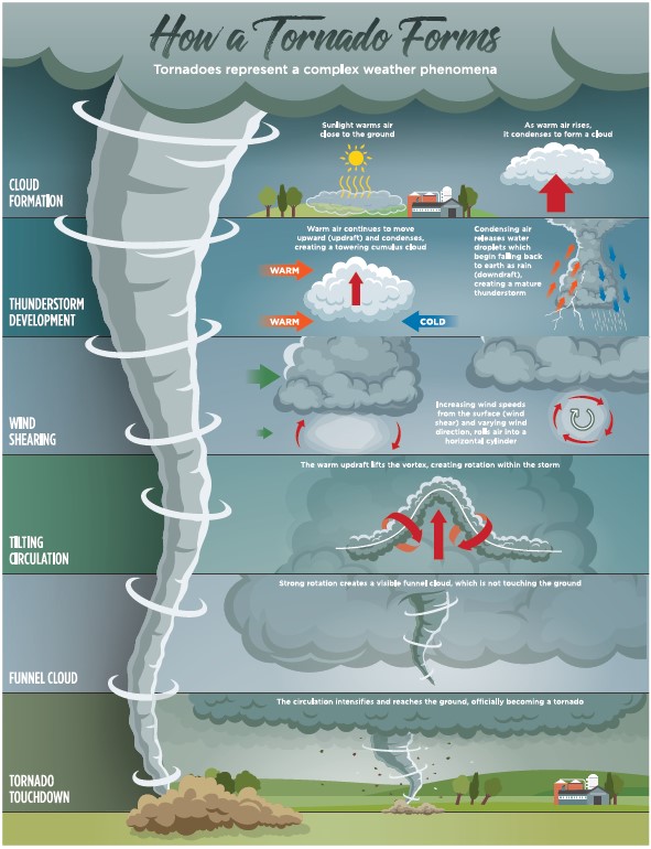
Now, here's where things get interesting and a little bit sneaky. We often have a layer of cooler, drier air sitting above that warm, moist air. This is what meteorologists affectionately call a "cap" or "lid." Sounds counter-intuitive, right? Like putting a lid on a pot you want to boil over? Precisely!
This cap acts like a pressure cooker. It traps all that energetic, warm, moist air below it, preventing it from rising too early. The warm air keeps heating up, getting more buoyant, more agitated, and building up incredible potential energy. It's like holding a giant, invisible beach ball underwater – it just wants to explode upwards. This cap keeps the atmosphere from becoming just a bunch of regular thunderstorms and instead lets it stew until it's absolutely furious. When that cap finally breaks? Oh boy, hold onto your hats!

The DJ: Wind Shear (The "Spin Cycle")
Okay, so we have a super-heated atmosphere just begging to launch itself skyward. But to get a tornado, we don't just need vertical movement; we need rotation. And that's where wind shear comes in, playing its wild, chaotic music.
Wind shear is essentially when winds at different altitudes blow in different directions or at different speeds. Imagine the wind near the ground is blowing south, but a few thousand feet up, it’s howling from the southwest, and even higher, it’s screaming from the west. This difference in wind speed and direction creates an invisible, horizontal "rolling pin" effect in the atmosphere. Think of it like a giant, invisible Slinky being stretched and twisted horizontally. It starts the entire lower atmosphere spinning, like a slowly rotating log.

This horizontal rotation is absolutely critical. Without it, you might get some impressive updrafts and big storms, but no twisters. It's the ingredient that gives the whole system its destructive twist, literally.
The Bouncer: A Kick in the Pants (The "Lifting Mechanism")
Finally, with all these volatile ingredients simmering away, we need something to initiate the main event. Something to give that pent-up, warm, moist air the green light to punch through the cap and go bananas. This is our lifting mechanism. It could be a cold front barging in, a dry line (where dry air meets moist air), or even just atmospheric waves. Something that provides that final shove, that "now or never" moment.

When that lifting mechanism shoves the warm, moist air upwards, it breaches the cap. And boy, does it breach it with force! All that stored energy explodes skyward in a massive, powerful updraft. This super-strong updraft then tilts that horizontally spinning "rolling pin" (from the wind shear) from horizontal to vertical. Voila! You’ve got yourself a rotating updraft, which is the heart of a supercell thunderstorm, the kind that spawns most tornadoes.
As this updraft continues to roar, it stretches and tightens that vertical column of spinning air, much like a figure skater pulling in their arms to spin faster. This intense, rapidly rotating column of air eventually descends to the ground as a visible funnel cloud, and then... a tornado. It's like the atmosphere doing an incredibly dangerous, high-speed ballet.
So, there you have it: a cocktail of warm, moist air, a sneaky cool cap, some twisting wind shear, and a good old-fashioned atmospheric shove. It’s a delicate, violent, and surprisingly specific recipe for one of nature's most spectacular and terrifying phenomena. Next time you see a storm brewing, you’ll know it’s not just rainclouds; it might be a symphony of ingredients, all playing their part in a cosmic drama. Cheers to that, and let’s hope those ingredients never quite align perfectly over our heads!
