Steps Of How A Tornado Forms

Hey there, ever wondered how those swirling, dramatic tornadoes actually get their act together? It’s not just Mother Nature having a bad hair day, though sometimes it certainly looks like it! I'm here to spill the beans, friend, on the incredible (and slightly terrifying) dance of atmospheric ingredients that concoct these spectacular storms. Don't worry, we're going to keep it super chill and easy to understand. Think of it as a behind-the-scenes tour, but for weather!
Step 1: The Stage is Set (Hello, Thunderstorm!)
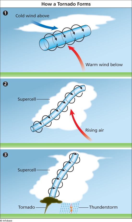
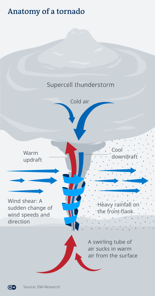
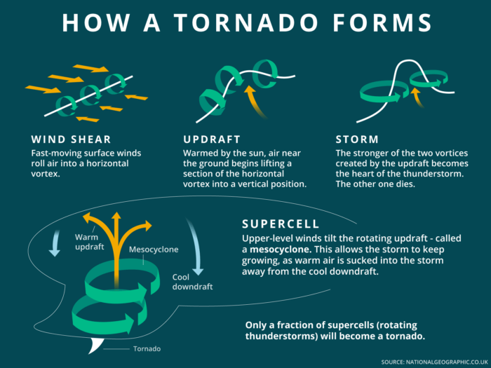
First things first, you can't have a tornado without a really impressive thunderstorm. We're not talking about your average sprinkles-and-a-rumble kind of storm here. Oh no, we need something a bit more… extra. We're looking for a special kind of super-thunderstorm called a supercell. These are like the rockstar thunderstorms of the weather world, known for their powerful, persistent rotating updrafts. Basically, they're big, mean, and have a lot of energy. Think of them as the bouncers at the door of the tornado club.
Step 2: The Plot Thickens (Wind Shear's Wild Ride)
Now, this is where things get interesting! Imagine you have winds blowing in different directions and at different speeds at various heights in the atmosphere. This fancy term for that is wind shear. It's like the air is doing a chaotic ballet – one layer is waltzing north, another higher up is doing the tango to the east, and maybe a third is breakdancing to the west. This creates a really unstable environment, which is exactly what our budding tornado loves. It’s like when you try to stir cake batter with two spoons going in opposite directions – total chaos, but also the start of something... delicious (or destructive, in this case!).
Must Read
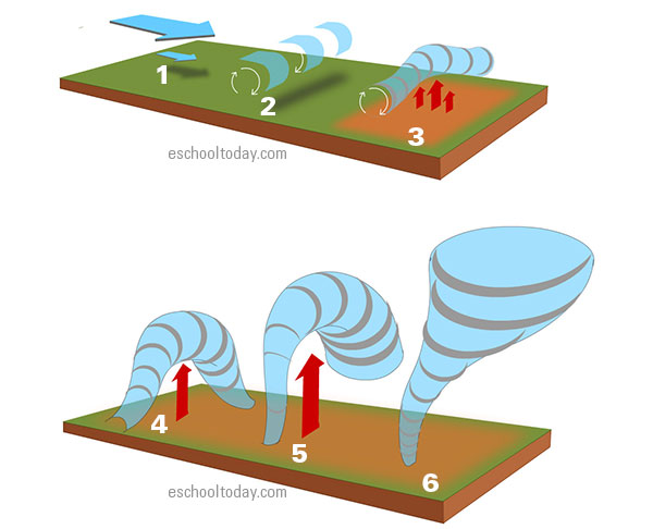
Step 3: Horizontal Hustle (A Rolling Start)
Because of that wild wind shear, something pretty cool (and a bit alarming) starts to happen. The air between these different wind layers begins to roll. Imagine a giant, invisible rolling pin in the sky. This rolling motion creates a horizontal tube of rotating air. Yep, just swirling horizontally, minding its own business for now. It’s like a log spinning on its side, just waiting for a nudge to stand up straight. This isn't a tornado yet, but it's definitely getting its groove on.
Step 4: Up, Up, and Away! (The Vertical Flip)
Remember those supercells we talked about in Step 1? Well, they're about to play a crucial role. Those storms have really powerful updrafts, which are basically columns of warm, moist air rapidly rising into the atmosphere. When one of these mighty updrafts encounters our horizontally spinning tube of air, it’s like a giant invisible hand grabbing that rolling pin and tipping it right up! Suddenly, that horizontal rotation becomes vertical. Ta-da! We've got ourselves a vertically spinning column of air within the storm.
Step 5: Spinning Like Crazy (Meet the Mesocyclone)
Once that horizontal spin is tilted upright by the updraft, it really gets going! This now vertically rotating column of air within the thunderstorm is called a mesocyclone. It's the heart of our future tornado and often pretty huge, sometimes several miles wide! At this point, the storm is seriously organized and spinning like a professional figure skater. If you could see inside the storm, you'd notice this massive, invisible carousel of air going round and round. Pretty impressive, right?
Step 6: The Visible Hint (Hello, Wall Cloud!)
As the mesocyclone strengthens and lowers, it often pulls down a specific part of the cloud base, forming what's called a wall cloud. This isn't always present, but when it is, it's a huge clue that something serious is brewing! A wall cloud is a localized, persistent lowering of the rain-free base of a thunderstorm, and it often rotates itself. It’s like the storm is clearing its throat and saying, "Alright, pay attention, folks, the main event is about to start!" If you see one of these babies rotating, it's definitely time to take notice!
Step 7: The Grand Finale (Tornado Time!)
Finally, if the conditions are just right – if the mesocyclone continues to intensify and stretch out – it can cause the air pressure inside its core to drop dramatically. As the air stretches and spins faster (think of an ice skater pulling in their arms to spin faster), it creates a narrow, violently rotating column of air that extends down to the ground. Voila! We have a tornado! The visible funnel cloud we see is actually formed by condensation as the air pressure drops, or by dust and debris being sucked up from the ground. It's the storm's way of saying, "Okay, I'm here, and I mean business!"
So there you have it! From a chaotic dance of winds to a towering supercell and eventually, that iconic swirling funnel. While tornadoes are incredibly powerful and demand our respect and caution, understanding how they form is a pretty neat insight into the incredible forces of our planet. It reminds us that even in nature's most dramatic moments, there's an awe-inspiring process at play. Stay curious, stay safe, and keep looking up at that amazing sky!