How Tornadoes Form Step By Step
Ever looked up at a brewing storm and felt that mix of awe and a tiny bit of apprehension? Tornadoes, those incredible, twisting columns of air, are one of nature's most dramatic shows. Learning how these meteorological marvels form isn't just for scientists; it's about satisfying our innate curiosity about the world around us. Plus, understanding them can even help us stay a little bit safer when the skies turn gray.
The purpose of diving into tornado formation is two-fold: first, it's genuinely fascinating to grasp the immense power and intricate dance of our atmosphere. Second, this knowledge empowers us. When you hear about severe weather outlooks, knowing the "why" behind them helps you appreciate the warnings and take them seriously. It's about demystifying one of nature's most violent phenomena, replacing fear with understanding.
In education, exploring tornadoes is a fantastic way to teach atmospheric science, physics, and even geography. Students learn about air pressure, convection, and the Coriolis effect. In daily life, this knowledge translates into being a more informed citizen. You might better understand your local weather alerts, recognize potential conditions for severe weather, or simply impress friends with your meteorological prowess at your next outdoor gathering. Think of it as developing a sharper "weather eye."
Must Read
Want to explore it yourself? Beyond watching captivating documentaries, you can start by paying closer attention to your local weather forecast, especially during severe weather seasons. Many weather apps and websites, like those from the National Weather Service (NWS), offer detailed radar and atmospheric data. Following reputable meteorologists on social media can also provide real-time insights and educational snippets. It’s a great way to watch the weather "live" as it happens, safely from your screen.
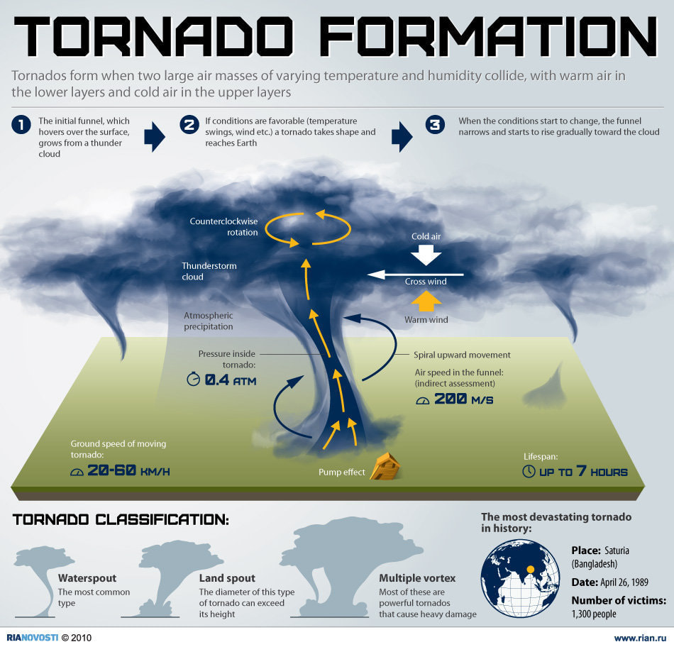
So, how do these incredible whirlwinds actually form? It all begins with a specific recipe for atmospheric instability, often involving the collision of air masses. You need a layer of warm, moist air near the ground, topped by cooler, drier air aloft. This creates an unstable environment where the warm air really wants to rise.
Next, we introduce wind shear. This is crucial: it's when wind speed or direction changes significantly with height. Imagine winds blowing one way at low altitudes and a different way (or much faster) higher up. This difference can cause air to start rolling horizontally, like an invisible, horizontal log spinning in the atmosphere.
Now, a powerful updraft enters the scene. As the warm, moist air rapidly rises (driven by that instability), it can lift and tilt that horizontally spinning air, causing it to stand on end. Suddenly, you have a vertically rotating column of air within the thunderstorm – this is called a mesocyclone. Supercell thunderstorms, which are responsible for most significant tornadoes, are characterized by these persistent, rotating updrafts.
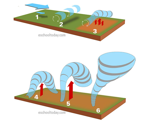
As the mesocyclone strengthens and tightens, much like a figure skater pulling in their arms to spin faster, the air pressure drops within its core. This low pressure causes the water vapor in the air to condense, making the rotation visible as a descending funnel cloud. Often, a distinct lowering from the storm's base, called a wall cloud, will form before the funnel appears.
Finally, when that visible funnel cloud makes contact with the ground, kicking up dust and debris, you officially have a tornado. Even if the visible funnel doesn't quite reach, if the circulation on the ground is causing damage, it’s still considered a tornado. It’s a breathtaking, albeit dangerous, reminder of the incredible forces at play in our atmosphere. Understanding these steps isn't just academic; it's about connecting with the raw power of our planet.