Ever wondered how those swirling behemoths of weather, hurricanes, actually come to be? It's a fascinating journey from a tiny ripple in the ocean to a roaring, rain-soaked force of nature! Understanding the steps of hurricane formation isn't just cool trivia; it can help us better prepare for these powerful storms and appreciate the incredible forces at play in our atmosphere.
Think of it like this: knowing the 'recipe' for a hurricane allows us to anticipate when and where one might develop. Weather forecasting relies heavily on understanding these stages, giving us valuable time to prepare our homes, businesses, and communities, ultimately minimizing damage and saving lives. Plus, let's be honest, it's pretty amazing to understand the science behind such a powerful phenomenon!
So, let's dive into the step-by-step process, starting with the very beginning:
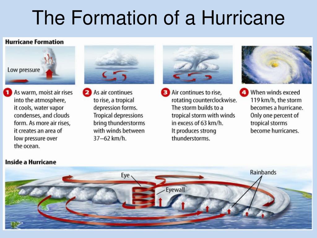
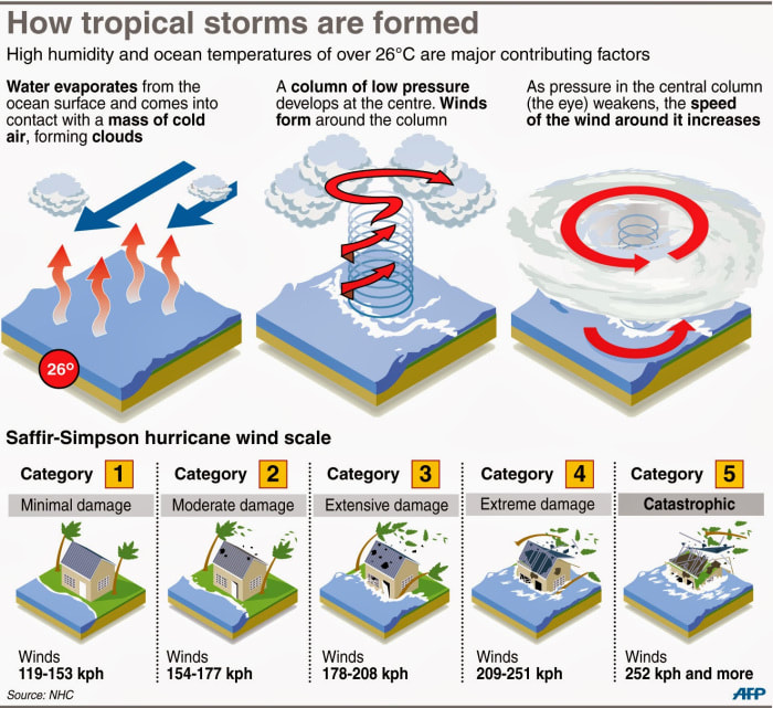
Step 1: The Tropical Disturbance. It all starts with a bit of atmospheric chaos! We're talking about a collection of thunderstorms that linger over warm ocean waters near the equator. These disturbances are often triggered by pre-existing weather patterns or even just a localized area of increased humidity and instability.
Step 2: Tropical Depression. If the conditions are right (think warm water, minimal wind shear), the thunderstorms can start to organize. The warm, moist air rises, creating an area of low pressure at the surface. This low pressure draws in more air, which also rises and cools, creating more thunderstorms. When this swirling system develops a closed circulation and sustained winds of 38 mph (61 km/h) or less, it's officially classified as a Tropical Depression.
Step 3: Tropical Storm. As the tropical depression intensifies, the winds pick up. If sustained winds reach 39 mph (63 km/h), the system is upgraded to a Tropical Storm and given a name from a pre-determined list (think names like Alex, Bonnie, Colin, etc.). This is when meteorologists really start paying close attention!
Step 4: Hurricane. This is the big one! If the tropical storm continues to strengthen, with sustained winds reaching 74 mph (119 km/h) or higher, it officially becomes a Hurricane. The hurricane's structure is now very well defined, with a central eye (a relatively calm area of low pressure), an eyewall (the most intense part of the storm, with the strongest winds and heaviest rainfall), and rainbands extending outward.
Step 5: Intensity and Landfall. Once a hurricane is formed, it's classified on the Saffir-Simpson Hurricane Wind Scale, ranging from Category 1 (least intense) to Category 5 (most intense). The intensity of a hurricane can fluctuate depending on environmental factors. Landfall occurs when the eye of the hurricane moves over land. This is often when the most significant damage occurs due to strong winds, heavy rainfall, and storm surge (a wall of water pushed onshore by the hurricane's winds).
Understanding these steps is crucial for understanding hurricane forecasts and warnings. Remember, staying informed is the best way to stay safe! So, the next time you hear about a tropical disturbance, you'll know exactly what's going on and how it might (or might not!) turn into a powerful hurricane.