Ever been mesmerized by a storm rolling in, the sky turning a dramatic grey-blue? Or perhaps you’ve felt a shiver of anticipation mixed with respect when a hurricane is mentioned in the news? Understanding the lifecycle of these powerful storms, specifically the stages of a hurricane, is not only fascinating but also incredibly relevant to our safety and awareness in an increasingly interconnected world. It's like understanding the plot of a thriller – you're more engaged and less likely to be caught off guard!
So, what's the point of knowing about hurricane stages? Primarily, it allows us to better predict and prepare for these natural disasters. By knowing the progression of a storm, meteorologists can more accurately forecast its intensity and path, giving communities crucial time to evacuate or reinforce their homes. This knowledge empowers us to make informed decisions about our safety and the safety of our loved ones.
Think of it like this: knowing the stages is like having a weather crystal ball, albeit a scientifically sound one! It helps us understand the 'story' the hurricane is telling. This knowledge also demystifies the process. Instead of a vague sense of dread, we gain a clearer understanding of the forces at play.
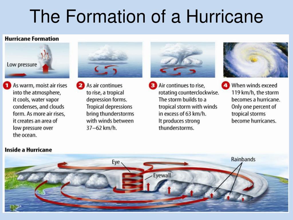
Let's break down the key stages: it all starts with a tropical disturbance. This is essentially a cluster of thunderstorms over warm ocean waters, typically near the equator. If conditions are right – low wind shear (minimal changes in wind speed and direction with altitude) and warm, moist air – the disturbance can organize and begin to rotate. This is where it becomes a tropical depression, characterized by a defined center and maximum sustained winds of 38 miles per hour or less. The depression gets a number assigned to it, like TD #9.
As the storm intensifies further, with sustained winds reaching 39-73 miles per hour, it graduates to a tropical storm. This is a significant milestone because the storm receives a name – remember Hurricane Katrina, or Hurricane Sandy? The storm's structure becomes more organized, with a noticeable circular pattern developing.
Finally, when sustained winds reach 74 miles per hour or higher, the storm officially becomes a hurricane (or typhoon or cyclone, depending on the region). Hurricanes are categorized on the Saffir-Simpson Hurricane Wind Scale, ranging from Category 1 (least intense) to Category 5 (most intense), based on wind speed. The scale helps estimate potential property damage.
In education, understanding hurricane stages is crucial for geography, science, and even social studies lessons. It can be used to illustrate weather patterns, atmospheric pressure, and the impact of natural disasters on communities. In daily life, this knowledge informs our decisions during hurricane season – when to stock up on supplies, when to evacuate, and how to prepare our homes. Even just understanding the weather forecast on the news becomes more meaningful.
So, how can you explore this further? One simple way is to track active storms on websites like the National Hurricane Center (NHC). Pay attention to the language used – are they referring to a "tropical depression," a "tropical storm," or a "hurricane"? Notice how the forecasts change as the storm progresses. You can also find animated simulations of hurricane formation and movement online. Learning about the science behind hurricanes helps us become more prepared and more resilient in the face of these powerful forces of nature.